Vectors & Rasters: the short version
When describing spatial data, the core thing to remember is that all GIS/geospatial data has two parts: the spatial part and the attribute part.
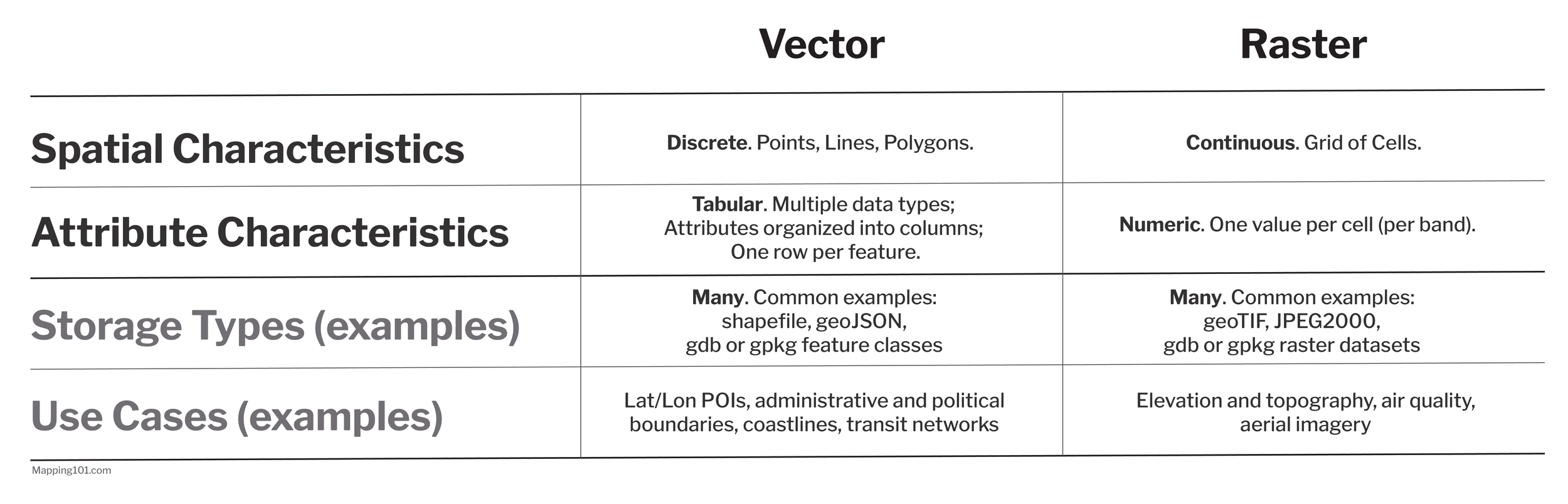
So, when we describe or compare GIS datasets, we describe the contents or structure of both halves as well as its storage format (file type).
Vectors
Spatial: Discrete. Vector data is spatially or geometrically discrete, with distinct point, polyline, or polygon features. These do not need to cover the entire extent of the dataset, and gaps between features are usually the case.
Attributes: Table of (Many) Values per Feature. Vector attributes are conceptually tabular (and often, but not always, are represented to “look like” tables in your working environment). Each feature corresponds to a row in the table. The table’s columns represent attributes which may contain a variety of data types (numeric, text/string, and so on). With this structure, each feature may be associated with many different attribute values within a single dataset.
Storage: Many. Vector data can be stored in a variety of formats. Among the most common are shapefiles, geodatabase or geopackage feature classes, and geoJSON files.
Rasters
Spatial: Continuous. Rasters are spatially continuous, with a grid of cells blanketing the full spatial extent of the dataset’s coverage area like a quilt. (These grid cells are often described as “pixels” because they share characteristics but are technically not pixels.) The geographic resolution of the dataset is determined by the scaled dimensions of the cell. For example, the Landsat 8 OLI sensor covers each scene with cells that correspond to 30 meters x 30 meters on the ground.
Attributes: One Numeric Value per Cell. Each raster cell holds one number, which may be an integer or a decimal value. This means we can conceptualize a raster dataset as a grid of values spread across a landscape. These numbers can represent quantities or might be coded indicators of categorical (qualitative) attributes. For example, they can represent elevation as meters above sea level or land cover with specific values labeling water, vegetation, or urbanized areas.
Storage: Many. Raster data, too, can be stored in a variety of formats. Among the most common are geoTIFFs, JPEG2000, or any other image type that can also hold georeference information.